Contact Us

Denise Aschleman - Assistant Director of Planning
- Business: (317) 776-6325
- Fax:
(317) 776-4638 - Staff Directory
- Hours: Monday - Friday
8:00 am - 4:30 pm
In this Department
- Building & Inspections
- Code Enforcement
- Current Planning & Zoning
- Flood Hazard Mitigation
- Plans and Studies
Board/Commission/Committee
- Architectural Review Board (ARB)
- Board of Zoning Appeals (BZA)
- Plan Commission (PC)
- Technical Advisory Committee (TAC)
- Meeting Dates and Filing Deadlines
Link or Service
Department Home
Topics of Interest
More Information
Find content and services related to this page.
Flood Hazard Mitigation
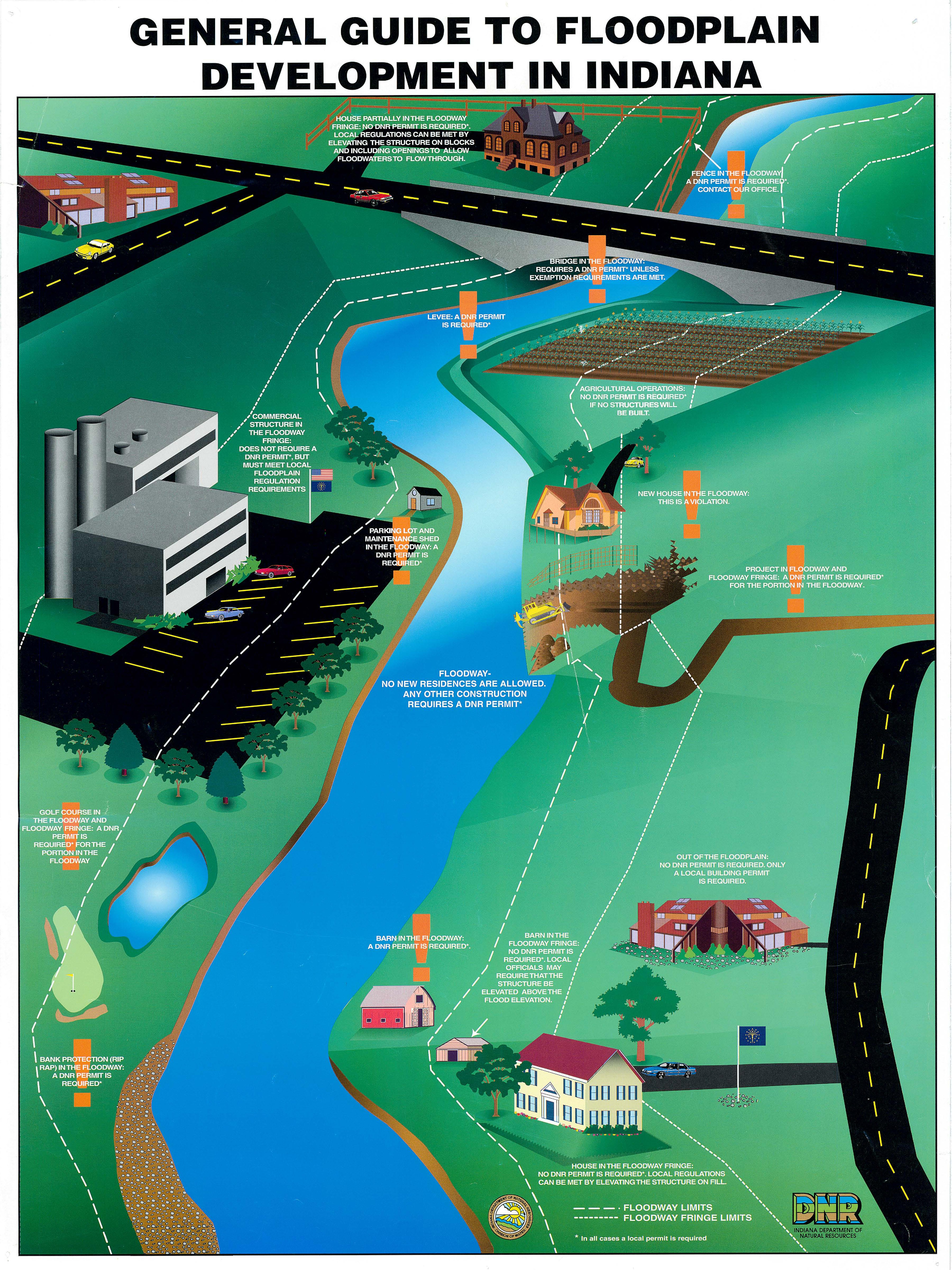
 Comprehensive flood hazard management is the most effective way to address flood control issues. It provides for a better understanding of the streams and floodplain systems and ensures that flooding problems are not simply transferred from one location to another within the watershed. The Hamilton County Multi-Hazard Mitigation Plan was developed with input from the general public, neighboring jurisdictions, the city's Planning Department and the city's Stormwater Division.
The National Flood Insurance Program's (NFIP) Community Rating System (CRS) was implemented in 1990 as a program for recognizing and encouraging community floodplain management activities that exceed the minimum NFIP standards. The National Flood Insurance Reform Act of 1994 codified the Community Rating System in the NFIP. Under the CRS, flood insurance premium rates are adjusted to reflect the reduced flood risk resulting from community activities that meet the three goals of the CRS: 1) reduce flood losses; 2) facilitate accurate insurance rating; and 3) promote the awareness of flood insurance. The City of Noblesville's Planning Department works closely with the Indiana Department of Environmental Management (IDEM), Indiana Department of Natural Resources (DNR), and the Federal Emergency Management Agency (FEMA) in evaluating the program as administered in the city.
The City of Noblesville has a number of resources that are available to our residents, but there are a number of resources now available on the web to gather more information. Specific floodplain information and inquiries may be made to the Indiana Department of Natural Resources using the INdiana Floodplain Information Portal. There are also a number of resources available from FEMA (Federal Emergency Management Agency. For information regarding flooding risks and flood insurance you can visit Floodsmart.gov. If you are looking for general information about programs that FEMA runs or the resources that they have available you can visit FEMA.gov. You can also find digital version of the currently adopted FIRM (Flood Insurance Rate Maps) on the FEMA Map Service Center. You may enter an address in the left bar on the website and it will find the correct map panel, or you may click the Product Catalog link at the top of the page and manually search for the correct map.
The City of Noblesville has a number of resources that are available to our residents, but there are a number of resources now available on the web to gather more information. Specific floodplain information and inquiries may be made to the Indiana Department of Natural Resources using the INdiana Floodplain Information Portal. There are also a number of resources available from FEMA (Federal Emergency Management Agency. For information regarding flooding risks and flood insurance you can visit Floodsmart.gov. If you are looking for general information about programs that FEMA runs or the resources that they have available you can visit FEMA.gov. You can also find digital version of the currently adopted FIRM (Flood Insurance Rate Maps) on the FEMA Map Service Center. You may enter an address in the left bar on the website and it will find the correct map panel, or you may click the Product Catalog link at the top of the page and manually search for the correct map.
Quick links - Additional Resources
- FEMA (Federal Emergency Management Agency)
- Floodsmart.gov
- Flood Insurance Rate Maps (FIRM)
- INdiana Floodplain Information Portal
- Indiana Department of Natural Resources (IDNR) Division of Water
- Indiana Department of Homeland Security (IDHS) Mitigation Division
- Hamilton County Emergency Management
- National Weather Service Advanced Hydrologic Prediction Service - Indianapolis Area River Gages
For more information on Noblesville's program contact our Certified Floodplain Manager Denise Aschleman at 317-776-6325 or [email protected].
